Some miles north of Drogheda, a little west of a fishing village called Clogherhead in the County of Louth, can be found this charming site. There is much more to see here than the small footprint of the site suggests. There is the ruin of a late medieval church, a graveyard with some very interesting features and also the remains of a motte. There is evidence on this small parcel of land of human settlement and activity covering a period of almost 1000 years.
Location, Topography and Maps

This site is relatively easy to find, just head for Clogherhead and proceed north-west out of the village, straight through a cross roads. Continue a little further until you see a turn off on the left to a local road. The entrance to the site is about 200 meters beyond this turn off. There is vehicular access, just proceed down the lane and you can park up right beside the graveyard.
I visited the site on a cold, yet gloriously sunny, afternoon in mid-January 2020. I cycled out from Drogheda on my ebike following an interesting loop from Drogheda, to Baltray, to Termonfeckin, to Clogherhead, and finally Mayne. There are interesting historical sites to see in all the aforementioned places but Mayne was the highlight of the day. Unfortunately, as this was my last stop, I had only a brief amount of time to explore the site but I intend to visit again soon, following which I will update and expand the observations recounted in this article.
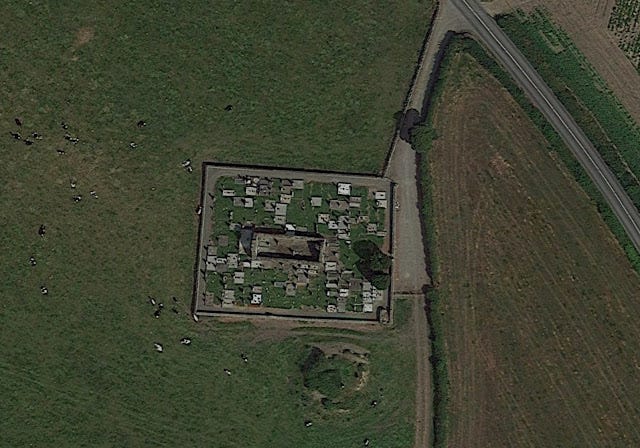
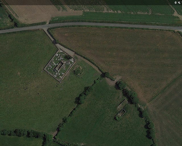
In the OSI Discovery Series map the site is marked as a Church and Motte. The map and the Google Earth images give an appreciation of how close the site is to the coast. Despite the relatively flat topography of the area the site itself is slightly elevated and the motte enjoys a commanding view of the surrounding landscape.
The following two satellite images allow an appreciation of the compact footprint of the site. The graveyard boundary wall, forming an almost perfect rectangle, is clearly visible as are the church ruins and motte. In the first image some other ruins are visible several hundred yards further along the lane.
While modern maps and photographs are an essential resource, often by examining old maps we can discover much about a site and how it once was before modern developments destroyed or altered the landscape. We can sometimes see details of towns, villages and buildings that are no longer visible.
The maps pictured above and below, from the Down County Survey 1654-1656, show us that Mayne formed part of Termonfeckin Parish. Unfortunately, there does not seem to be a more localised, detailed map of the Mayne area which may have told us a little more about the site.
For greater detail we need to examine 19th Century maps. These maps, and the previously mentioned OSI Discovery Series map, are best viewed on the wonderful Heritage Maps website, provided by the Heritage Council.
There are two ways to find this location on the map. Once you load it up, you can search by townland on the top left of the screen by entering the name in the searchbar. "Glebe East" is what you are searching for, there are a number of returns so click through them until you find the correct one.
Alternatively, you can click here, which will open the map on the correct location in a new browser tab. You can then click on the green basemap button on the bottom of the map to select the different maps discussed below. To make things easier and avoid confusion, I have used the same name for the individual maps as they have in the Heritage Maps platform.
By looking at these maps we can see that much is the same now as it was in the 19th Century.
In the Historic 6 Inch BW we can see that much of the streetscape is the same today as it was in the mid 19th Century. The Church is annotated as being "in ruins", and the motte (moat) and graveyard are clearly illustrated. One major difference to what we find in Mayne today are the multiple buildings located in close proximity to the site. Not much remains today, except perhaps for the ruins previously mentioned which are visible in the satellite/aerial photographs.
There isn't much different to note in the Historic 6 Inch CL map compared to the black and white version discussed above, but it is interesting to look at in any case.
The Cassini 6 Inch map is more modern than the previous two maps. Here we can see some development where some buildings have cropped up, one of which is almost on top of the motte. We can see that the church and graveyard are located in the townland of Glebe East, and the motte just outside it.
Mayne Church
Glebe East Church or "Old" Mayne Church dates from the later medieval period, the 1500's or 1600's. The church is of the undifferentiated nave-and-chancel design. O'Keefe defines these as churches that are "long enough to have clearly demarcated spaces within them, but the separation between the public and sanctuary spaces are not marked externally". That is to say, it looks from the outside as one long building with no obviously differentiating sections.
At this point it may be useful to explain what is meant by "nave" and "chancel".
The nave of a church is, in basic terms, the space where the laity (the non clerical public) congregate or sit. It is the bit, in modern churches, where the pews are. In larger churches with side aisles only the central aisle is defined as the nave. The chancel is the bit of the church surrounding the altar where, traditionally, only clergy were allowed. In medieval times the nave was often separated from the chancel by a screen.
Mayne Church follows the usual orientation on the east-west axis. The altar is located at the eastern end, with the nave on the western. The building itself is of somewhat basic and rude construction featuring largely unworked greywacke and limestone. (Greywacke is a form of sandstone rock which is plentiful in the area). There are some cut stones used around the doorways, of which there are two, located opposite of one another in each wall. The cut stones are probably stones which were prepared for an older building and were reused in the construction of this church. The walls are approximately 2.7 meters in height with the gable ends tapering higher. The interior of the church has been used for burials and there are a number of memorial stones contained within the ruin.
There were three main features of interest which I observed on my regrettably brief visit: The east gable, the west gable and the stone basin. I will discuss each of these in turn below.
The East Gable
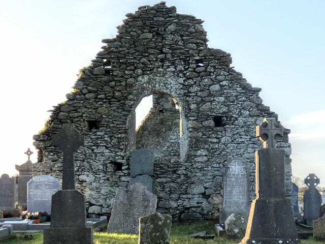
The east gable (the altar end) features a large, roughly arched window opening. Formally this opening contained a fine two-light window with trefoil-pointed arches and glazing grooves (drawing below). It was constructed of punch-dressed sandstone. By all accounts, this window was somewhat roughly inserted and was out of keeping with the form of the rest of the building. This suggests that the window was reused in the extant building, perhaps taken from an earlier building on the site along with the previously mentioned cut stone. The design and form of the window suggest an origin date of sometime in the 13th century - although it could also be late medieval.

The east gable interior also features some of the original plaster which can be seen in the photograph above.
The West Gable
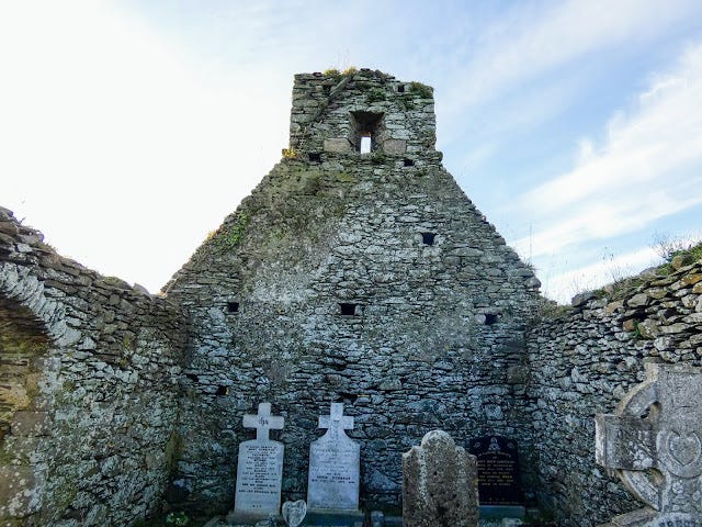
There are a couple of interesting features to the west gable. Firstly, we can see eight 'holes' in the inner facade of the gable. These are 'put-log' holes used to support beams, usually for scaffolding.
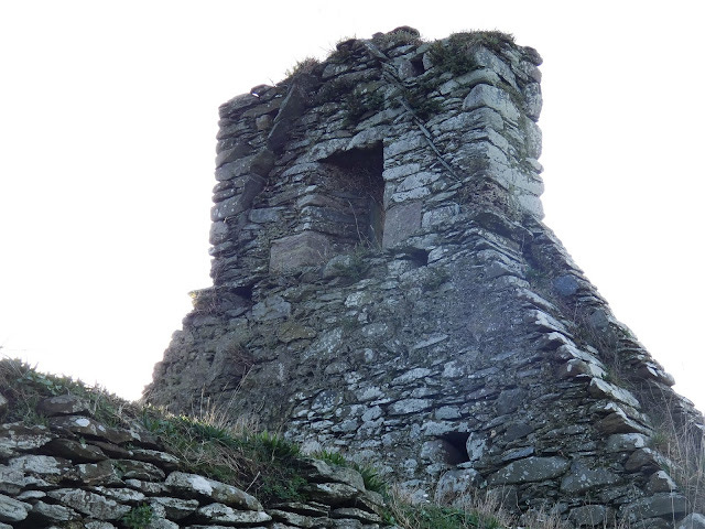
There is a single window opening, above which there was a double bellcote, now destroyed. In a bellcote a bell is supported on a horizontal bar. Double bellcotes are fairly common in Ireland, moreso than single bellcotes. The exact usage of the bells is a matter of some debate, but one popular belief is that one bell was reserved for mass and the other was used for everything else.
In the photograph above, the outline of the roof peak is clearly visible. Resembling an upside down letter V, some of the original slates protrude from the gable clearly showing the height of the roof. The bellcote protruded above the peak of the roof, and perhaps looked something similar to the double bellcote of Killybegs Church, County Kildare, pictures of which you can be viewed on the wonderful 'Visions of the Past" blog.
The Stone Basin
On the southern wall, close to the east gable, can be found a stone basin-like construction recessed into the wall. This location, close to the altar and chancel area, suggests that this "basin" is a piscina or a lavabo.
A piscina is a basin in which the Priest would wash vessels which were used for sacred purposes during Mass. A lavabo, however, is a basin in which the Priest would ritually wash his hands. A piscina would usually have a drain of some sort in it, whereas the lavabo is a more conventional basin. To confuse things a little further, the two terms tend to be used interchangeably. On my visit I neglected to take a photograph of the inside of the basin, but from what I recall there is no "drain". Hence this basin was probably used for the ritual washing of hands. On my next visit I will investigate this further!
The Graveyard
On my visit I mainly preoccupied myself with the ruin and adjacent motte, I neglected to properly explore and appreciate the graveyard which appears to be still in use, an elderly couple were paying their respects at a grave when I arrived.
I idly noticed that many of the memorials looked several hundred years old, but I did not inspect them any further. However, while researching for this piece I discovered that there is much of interest to be seen, with a number of memorials dating from the 18th Century, complete with some intricate carvings. On my next visit I will investigate these further, take some photographs and update this section of the article accordingly to pay full tribute to what is a fine graveyard.
For the time being I will look at what seems to be the most interesting of these memorials, one which is located within the ruin of the church, adjacent to the western gable. This gravestone is dedicated to a "Reverend James Corrigan, Pastor of Termonfecken" who died at the age of 49 on the 23rd November 1795. Of the carvings, pictured below, that of the priest replete in vestments and the "memento mori" (remember you will die) reliefs are the most striking.
The graveyard also contains, in the south-east corner, what appears to be the remains of a "watch-house". Watch-houses were built at many graveyards in times past, they were built to try and prevent "bodysnatchers" from stealing the corpses of the recently deceased. Bodysnatchers engaged in this macabre trade mainly to supply anatomy schools and the like with cadavers to practice and experiment upon. The families of the recently deceased would employ watchmen to keep an eye on things from the graveyard's watch-house until a sufficient amount of time had passed for the deceased's body to have decayed to a level at which anatomy schools would have no interest.
The Motte
A motte (sometimes spelt as mote or moat) is essentially defined as a flat-topped earthen mound often surrounded by a rampart and/or a ditch/fosse. They are often associated with a secondary, connected enclosure called a bailey. A great example of a motte and bailey can be seen at Millmount in the nearby town of Drogheda. The motte at Glebe East/Mayne has no evidence of any bailey, rampart or ditch.
Mottes were typically constructed by the Normans in the 1100s and 1200s and could be erected quite quickly. The newly piled earth was generally unable to provide a firm foundation for a stone building so a wooden structure, sometimes quite basic, was typically erected on top of the mound.
Mottes are military structures, built by the Normans to aid conquest of new territory, to consolidate their gains and also to just generally secure their holdings. Mayne does not appear to be have been at the frontier of the Norman's holdings, and just who built it is a mystery, but a date sometime in the early Norman period seems appropriate which could suggest that it was built by either the De Lacy's or the De Verdon's.
Sometimes motte builders took advantage of pre-existing mounds in the landscape such as passage graves, or as is the case at Mayne, Glebe East, middens.
A midden, in basic terms, is a refuse heap. They can be located near the shore and often are made up of piles of shells, bones and the like. They are often associated with a settlement. (Presumably people didn't walk miles from their homes to prepare food and dump the leftovers!). At Glebe East, it appears that the builders took advantage of the existence of two middens to give them a "head start" on the motte. The motte appears to be almost contemporary in age to the middens. We can tell this because, when the layers were examined, there was no layer of sods between the middens and the mass of earth and gravel that the motte builders heaped on top. If the middens were old when the motte builders commenced increasing the size of the mound you would expect that grass etc. would have grown over the deposits. As there is no evidence of this we can assume that the middens were relatively "fresh" when the motte builders arrived. It is not unreasonable to speculate that the middens were a by-product of native life disturbed and perhaps displaced by the Norman castle builders.
The Middens at Glebe East/Mayne consist of a large amount of mollusks, animal bone some charcoal and ash, as well as stones etc. The "motte layers" piled on top to build the flat-topped mound primarily consist of sandy clay, gravel and stone. These "motte layers" make up the majority of the mound.
The motte as it stands today represents what must be a much-reduced version of what the motte was in its prime. The motte measurements, as per the archaeological record, are as follows: "max diam. at base 29m, at summit 11m, H c. 4m."
There are some records which indicate that gravel may have been extracted from the site in the 1800s and the Cassini map previously discussed shows a building that is almost on top of the motte, the construction and later removal of this building must have caused some damage. Over the years agriculture has caused some damage too, with the close passage of farm machinery and the presence of cattle leaving their mark.
While I did not have time to clamber up what remains of the motte on my visit (yet another reason to return!) it is an elevated site which must give a commanding view of the surrounding area, right down to the coast.
Concluding Thoughts
The site at Mayne, in the townland of Glebe East in County Louth is very much worth a visit. Aside from the features of the site, some of which are discussed above, the site enjoys that indefinable magic with which all antiquarians are acquainted. Here can be felt the weight of almost 1000 years of history. I can't wait to return for another, longer visit in the, hopefully, near future (at the time of writing Ireland is under coronavirus-related lockdown) . When I return I shall more closely examine and photograph the graveyard, motte and church and I shall publish the outcome here by updating this post.
There are some other posts and articles on the internet about this site, often with some magical photographs. I hope that my article may be of use to someone looking to find out more about this fascinating site. My writing is more of an interpretation and collation of extant information than a completely original investigation and research. I have listed below my sources and references. They, particularly the articles in the Journal of the County Louth Archaeological Society, are a wealth of information. Please check out the CLHAS website, https://clahs.ie/, and consider joining. But above all, try and visit the site if you can. The whole area is full of historical sites, some of which I will post about in due course.
References and Further Reading
Journal Articles
Recycled Ringforts: The Evidence from Archaeological Excavation for the Conversion of Pre-Existing Monuments to Motte Castles in Medieval Ireland, Cóilín Ó Drisceoil, Journal of the County Louth Archaeological and Historical Society Vol. 25, No. 2 (2002), pp. 189-201 (13 pages)
An 18th-Century Priest's Memorial Stone at Mayne, Co. Louth, A. K. Longfield, Journal of the County Louth Archaeological Society, Vol. 11, No. 3 (1947), pp. 204-205 (3 pages)
Old Churches in County Louth. (Continued), O. Davies, Journal of the County Louth Archaeological Society, Vol. 10, No. 4 (1944), pp. 277-296 (21 pages)
Gravestone Inscriptions in Mayne, Patrick Mallon and Noel Ross, Journal of the County Louth Archaeological and Historical Society, Vol. 20, No. 4 (1984), pp. 340-355 (16 pages)
Maps
http://downsurvey.tcd.ie/index.html (Down Survey Maps)
Other Blogposts/Websites
http://irelandinruins.blogspot.com/2019/08/old-mayne-church-co-louth.html
http://irishantiquities.bravehost.com/louth/glebeeast/glebeeastchurch.html
Books
O'Keefe, Tadhg, 'Medieval Irish Buildings 1100-1600', Four Courts Press, 2015
'Archaeological Inventory of County Louth' (Dublin: Stationery Office, 1986)
'Archaeological Survey of County Louth' (Dublin: Stationery Office, 1991).


